
Southern California's Premier OHV Destination
The Ultimate Hungry Valley SVRA Guide
Everything you need to know about Hungry Valley State Vehicular Recreation Area: trails, camping, fees, regulations, and expert riding tips.
Explore the Complete GuideIMPORTANT: Post Fire Closures
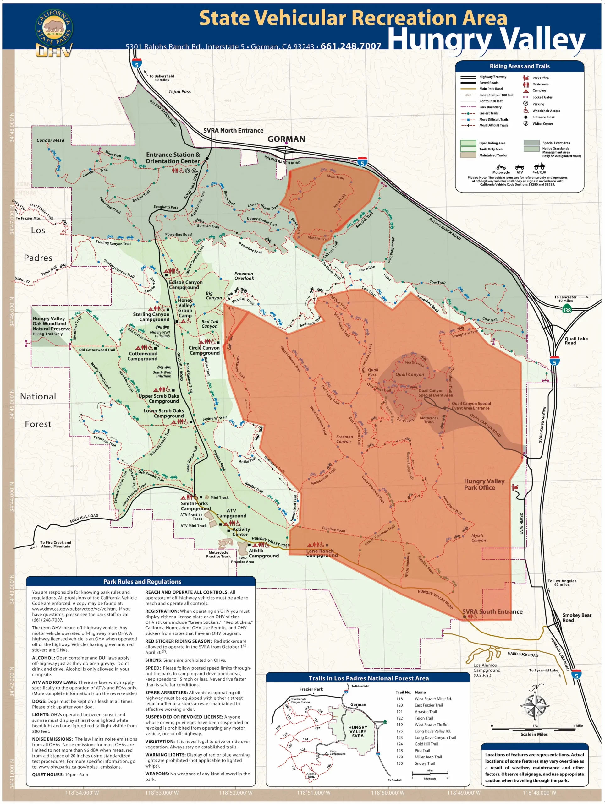
As of December 2025, large sections of Hungry Valley remain closed following the June 2024 Post Fire which burned 10,064 acres. Only the North Entrance and select areas are open for recreation.

Green areas are open • Orange areas are closed
Download Map
Start Here: Choose Your Path
Epic Adventure Story
Want to know what riding Hungry Valley is really about? Read about my epic adventure into the Los Padres National Forest.
Two Strokes and Thin Air
A personal story of brotherhood, altitude, and the kind of ride that changes you—three riders, nearly 4,000 feet of climbing, one breakdown, and an unforgettable day in the mountains.
Complete Beginner
First time at Hungry Valley? Start with fees, requirements, and family-friendly areas.
What You Need to Know
- Cost: $5 day use fee per vehicle
- Required: OHV registration, spark arrestor, DOT helmet
- Weekend visits: Reservations required via LAZ Parking app
- Hours: Weekdays 7am-6pm, Weekends 6am-6pm
Family-Friendly Tip
Smith Forks Campground has flush toilets (rare at OHV parks!) and direct access to the mini MX track—perfect for kids learning to ride.
Intermediate Rider
Ready to explore? Check out trail guides and pro riding tips.
Post Fire Status
As of November 2024, approximately 70 miles of western trails are accessible. Eastern and southern portions remain closed for recovery. Check Chapter 3 for current trail status before planning your ride.
Family Camping
Planning a family trip? Explore campgrounds and beginner-friendly areas.
Camping Quick Facts
- Cost: $10 per night (includes day use fee)
- Availability: First-come, first-served (50 sites limit)
- Campgrounds: 9 currently open post-fire
- Best for Families: Smith Forks (flush toilets, mini MX track)
Pro Family Tip
Powerline Road is the perfect beginner trail—wide, gentle terrain with spectacular views. Great for kids building confidence and families riding together.
Local Regular
Check current trail status and closure updates.
Current Status (November 2024)
Following the June 2024 Post Fire, approximately 70 miles of western trails remain open. Eastern and southern portions are closed for recovery.
Open: North Entrance, West Area trails, all 9 campgrounds
Closed: South Entrance, Quail Canyon, eastern/southern backcountry
Weekend Reservation Reminder
Weekend visits require advance reservations through the LAZ Parking app or website. Weekday entry is first-come, first-served until the 103-vehicle daily limit is reached.
Complete Guide: 18 Chapters
Deep dive into every aspect of Hungry Valley SVRA. Each chapter is packed with detailed information, tips, and actionable guidance.

1. Introduction & Overview
Discover what makes Hungry Valley special: 19,000+ acres of diverse terrain, rich history, and why it's a premier destination for OHV enthusiasts.
Read Chapter →
2. Entrance, Rules & Requirements
Everything you must have before riding: OHV registration, spark arrestor requirements, helmet laws, sound limits, and park rules.
Read Chapter →3. Post Fire Recovery & Current Status
Complete breakdown of the June 2024 Post Fire impact, current closures, what's open, recovery timeline, and what to expect when visiting.
Read Chapter →4. Open Trails & Riding Areas Guide
Detailed guide to currently open trails and areas: difficulty ratings, terrain types, GPS coordinates, and what to expect on each trail.
Read Chapter →
5. Closed Trails Archive
Historical information about closed trails and areas, why they're closed, and projected reopening timelines (when available).
Read Chapter →
6. Trail Rating System & Difficulty Guide
Understand our trail difficulty ratings from beginner-friendly to expert-only, terrain types, and how to choose the right trail for your skill level.
Read Chapter →
7. 4WD Practice Area Deep Dive
Complete guide to the 4WD training area: obstacles, difficulty progression, vehicle requirements, and tips for conquering each challenge.
Read Chapter →
8. Camping Overview & Facilities
Overview of all campgrounds, facilities, amenities, reservation systems, fees, and what to expect at each camping area.
Read Chapter →
9. Featured Campgrounds Deep Dive
In-depth reviews of each campground: site layouts, hookups, nearby trails, amenities, photos, and insider tips for the best experience.
Read Chapter →
10. Trip Planning & Itineraries
Plan your perfect Hungry Valley trip: suggested itineraries by skill level, what to pack, best times to visit, and sample ride loops.
Read Chapter →
11. Pro Tips & Riding Techniques
Expert advice for riding Hungry Valley's unique terrain: desert riding techniques, elevation challenges, and skills for mixed terrain.
Read Chapter →
12. Safety, Emergency & First Aid
Critical safety information: emergency contacts, nearest hospitals, first aid essentials, what to do in an emergency, and prevention tips.
Read Chapter →
13. Weather & Seasonal Considerations
When to visit, seasonal conditions, temperature ranges, precipitation patterns, and how weather impacts trail conditions and riding.
Read Chapter →
14. Geology, History & Natural Features
Understand the landscape: geological formation, ecological zones, native wildlife, historical context, and what makes this area unique.
Read Chapter →
15. Fun Facts & Unknown Unknowns
Fascinating trivia, lesser-known facts, insider secrets, and things even experienced riders might not know about Hungry Valley.
Read Chapter →16. Frequently Asked Questions (FAQ)
Answers to 60+ common questions about fees, rules, camping, trails, gear, seasonal closures, and everything else you need to know.
Read Chapter →
17. My Epic Ride At Hungry Valley
Two Strokes and Thin Air: A personal story of brotherhood, altitude, and the kind of ride that changes you — three riders, nearly 4,000 feet of climbing, one breakdown, and an unforgettable day in the mountains.
Read Story →
18. Sources, Citations & Appendices
Complete list of 50+ official sources, regulations, maps, downloadable resources, and reference materials used throughout this guide.
View Sources →Quick Answers
Get immediate answers to the most critical questions (click to expand)
Before you arrive at Hungry Valley, you must have:
- Valid OHV Registration: Green or Red sticker from California DMV, or reciprocal state registration
- Spark Arrestor: USFS-approved spark arrestor installed on your exhaust
- Sound Limit: 96 dB or less at 20 inches from exhaust (strictly enforced)
- DOT Helmet: Required for all riders under 18; strongly recommended for adults
- Day Use Fee: $5 per vehicle (pay at entrance kiosk)
Failure to have these items will result in being turned away at the entrance or cited by rangers.
Read Full Requirements →In case of emergency:
- 911: Police, Fire, Medical Emergency
- Park Rangers: Call 661-248-6692 (office hours) or 661-858-2800 (Sector headquarters)
- Nearest Hospital: Henry Mayo Newhall Hospital, 23845 McBean Pkwy, Valencia, CA (approx. 30 minutes south)
- Alternative: Kern Medical Center, 1700 Mount Vernon Ave, Bakersfield, CA (approx. 45 minutes north)
Important: Cell phone coverage is limited throughout the park. Always ride with a buddy and carry a first aid kit.
Read Full Safety Guide →For beginners and families, we recommend:
- North Entrance Family Area: Gentle terrain, wide trails, minimal obstacles
- Honey Valley Group Camp Trails: Easy loops close to camp with good sight lines
- Edison Day Use Area: Beginner-friendly trails radiating from day use parking
Pro tip: Start with short 30-minute rides to build confidence, then gradually increase distance and difficulty.
View Trip Planning Guide →Best times to visit:
- Spring (March-May): Ideal temperatures (60-75°F), green landscapes, wildflowers
- Fall (October-November): Comfortable riding conditions (65-80°F), less crowded
- Summer (June-September): HOT (90-105°F+), ride early morning only, high fire danger
- Winter (December-February): Cold (30-50°F), possible snow above 4,000ft, muddy trails after rain
Warning: Summer temperatures can exceed 100°F. Always carry extra water, start early, and watch for heat exhaustion signs.
Read Weather Guide →